Lanarkshire
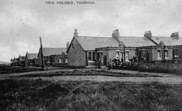 | 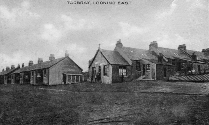 |
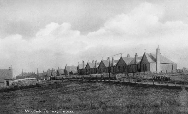 | Various views of Tarbrax |
Other Lanarkshire resources on this site:
There are extensive extracts on Lanarkshire in the 1842 Commission reports and also the Mining District Reports. Lanarkshire housing is covered in the 1918 Royal Commission Report, the 1910 Housing report and the 1875 Notes on Miners' Houses. Many Lanarkshire places are covered in the 1871 Truck report.
The following parishes have their own pages:
- Blantyre
- Bothwell
- Cambsunethan
- Dalserf
- Hamilton
- New Monkland
- Old Monkland
- Shotts
- Leadhills is covered in the Lead Mining section
Gazetteer Descriptions
The following websites contain on-line versions of Groome's Ordnance Gazetteer of Scotland and Samuel Lewis Topographical Dictionary of Scotland.Ordnance Gazetteer of Scotland, Francis H Groome
Auchenheath, a collier village in Lesmahagow parish, Lanarkshire, 2½ miles N of Abbey Green. Standing on the right bank of the Nethan, it has a station on the Lesmahagow branch of the Caledonian, and boys' and girls' schools, with total accommodation for 312 children, an average attendance (1879) of 152, and grants amounting to £138,12s. 3d. Two coal pits, at work here in 1879, belong to the Carboniferous Limestone series, and furnish fine cannel coal, employed in the Glasgow and other gas-works. Pop. (1861) 716, (1871) 763, (1881) Boreland, a farm in Walston parish, Lanarkshire. A brass tripod, supposed to be Roman, was exhumed on it by the plough, and two caverns on it, one of them 40 feet long and 5 feet high, are believed to have been formed by mining operations in the reign of James V.
Cambuslang, a quasi-town and a parish of NW Lanarkshire. The quasi-town stands on broken ground, traversed by a romantic brook, adjacent to the Glasgow, Uddingstone, and Motherwell branch of the Caledonian railway, within ½ mile of the Clyde's left bank, 3¾ miles SE of Glasgow; extends slightly into Rutherglen parish; consists of a cluster of five villages-Silverbanks, furthest W; then Cambuslang proper; then Kirkhill, the original village; then the hamlet of Lightburn; and lastly that of Dalton. Bearing aggregately and popularly the name of Cambuslang, it presents, from many points of view, a finely picturesque appearance; consists chiefly of very plain houses; is inhabited principally by weavers and colliers, partly by masons and agricultural labourers; and has a station on the railway, a post office under Glasgow, with money order, savings' bank, and telegraph departments, a branch of the Commercial Bank, gas-works, a handsome parish church (1841; 1000 sittings) with a conspicuous spire, a Free church with another fine spire, an Independent chapel (1801), and St Bride's Roman Catholic church (1878; 500 sittings). A spacious natural amphitheatre, on the green side of the ravine of the intersecting burn, a little E of the present parish church, served in 1742 as a substitute for the church of that date, from 8 Feb. to 15 Aug. being the scene of a remarkable religions revival,-the Camb'slang Wark,- when, to quote the late Dr Hill Burton, in an encampment of tents on the hill-side, Whitfield, at the head of a band of clergy, held, day after day, a festival, which might be called awful, but scarcely solemn, among a multitude, calculated by contemporary writers to amount to 30,000 people.' The centenary of the revival was commemorated on 14 Aug 1842, by tent preaching in the ravine, and was attended by a multitude of persons variously estimated at from 10,000 to 12,000. A chapel on the edge of the ravine, near Sauchiebog, was founded in 1379, and dedicated to the Virgin Mary; and has bequeathed the name of Chapel-land to a plot of about 4 acres around its site. Pop. (1881) of Cambuslang village, 4772; of other villages, 4318. The parish contains also groups of houses at NewtonColliery, Flemington-Colliery, and the Steel Co. of Scotland Works at Hallside. It is bounded N by the river Clyde, separating it from Old Monkland; E by the Rotten Calder, separating it from Blantyre; S by East Kilbride; W by Carmunnock; and NW by Rutherglen. Its greatest length, from N by E to S by W, is 3¾ miles; its greatest breadth is 3½ miles; and its area is 5209 acres, of which 49 are water. The surface is beautifully diversified with hill and dale. From less than 50 feet above sea-level along the Clyde, the surface rises towards a ridge, which, crowned by the summits of Dechmont (602 feet) and Turnlaw (553), occupies a breadth of about ½ mile and a length of 2 miles in the SW, and is part of a long range extending westward along the mutual border of Lanark and Ayr shires into Renfrewshire. The ground thence declines in a gradual manner, with beauteous irregularities and undulations, to the romantic glen of the Calder and to the low flat banks of the Clyde. The latter river is here from 200 to 250 feet broad; generally overflows part of the low grounds several times in the year; and has been known to rise 20 feet above its usual level. The rocks beneath the low lands belong to the Carboniferous formation. Coal is plentiful, has been worked for upwards of 300 years, and yields a large annual output; whilst ironstone also abounds, but has been worked on only a small scale. Limestone, so fine as to be known as 'Cambuslang marble,' is interstratified with some of the coal seams at a depth of 200 feet; has a beautiful dark grey or dark brown colour, with whitish streaks and spots; is capable of a very high polish; and has been used for ornamental purposes. Sandstone, of various colour and grain, from whitish to red and from fine to coarse, is plentiful, and has been largely quarried for building purposes. Trap rock abounds in the hills; and a hard bluish kind of it, interspersed with veins of red, blue, and violet quartz, is quarried on the E side of Dechmont. The soil on the hills is light and stony; along the banks of the Clyde is partly a light loam, partly a light sand; and elsewhere is mostly clay on a tilly subsoil. Very little land is waste or uncultivated. Chief antiquities are traces of ancient buildings on the summit of Dechmont, vestiges of Drumsargard Castle, 1¾ mile ESE of the parish church; Latrick mansion, of the 17th century, on the S side of Dechmont; and the site of an ancient hospital at Spittal, 2½ miles SE of the church. Rt. Fleming (1630-94), author of The Fulfilling of the Scripture, was minister from 1653 to 1662 of Cambuslang, where was born his son and namesake (d. 1716), author of The Rise and Fall of the Papacy; another native was the Indian Evangelist, Clandins Buchanan, D.D. (1766-1815); and Gilbertfield gave designation to Wm. Hamilton (1670-1751), Allan Ramsay's friend and brotherpoet. The principal mansions are Gilbertfield, Newton, Westburn, Caldergrove, Hallside, Morriston, Wellshot, and Millheugh; and 4 proprietors hold each an annual value of £500 and upwards, 11 of between £100 and £500,14 of from £50 to £100, and 27 of from £20 to £50. Cambuslang is in the presbytery of Hamilton and synod of Glasgow and Ayr; the living is worth £525. Three public schools (Bushy Hill, Kirkhill, and Newton), Cambuslang Industrial school, and St Bride's Roman Catholic school, with respective accommodation for 278,300,250,117, and 253 children, had (1880) an average attendance of 283,286,153,29, and 172, and grants of £205, £250,5s., £139,4s. 6d., £27,19s. 6d., and £121,12s. Valuation(1860)£15,003, (1881)£56,565, 3s. 4d. Pop. (1801) 1558, (1831) 2697, (1861) 3647, (1871) 3740, (1881) 9447.—Ord. Sur., shs. 23,31,1865-67.
Carluke, a town and a parish of central Lanarkshire. The town stands on the right bank of Jock's Burn, 1/2 mile E of the Caledonian railway, 2 1/4 miles E of the Clyde, 5 1/2 NNW of Lanark, and 19 1/2 SE of Glasgow. Its site is a swell of tabular land, rising somewhat steeply from the picturesque ravine of Jock's Burn; has an elevation of between 600 and 700 feet above sea-level; and commands an extensive and brilliant view over nearly all the central portions of the basin of the Clyde. Dating from early times, the town was constituted a burgh of barony, under the name of Kirkstyle, in 1662, but declined so greatly that about the middle of last century it comprised only the parish church, the manse, and four cottages. It afterwards rose to a considerable village, inhabited chiefly by cotton-weavers; and, making a strong start in prosperity about the beginning of the present century, it rapidly assumed the appearance of a thriving town, acquired a new character and much importance from the commencement and progress of extensive mining operations in its neighbourhood, and is now a neat, well-built place, with numerous streets of substantial and comfortable houses. It is a centre of traffic for a considerable extent of surrounding country; is well supplied with shops in all the ordinary departments of retail trade; and has a post office, with money order, savings' bank, insurance, and telegraph departments, a railway station, branches of the National and British Linen Company's banks, a savings' bank, 14 insurance agencies, 5 hotels and inns, a gas-light company, agricultural and horticultural societies, a useful knowledge society, with library and museum, and several religions and charitable institutions. Cattle markets fall on the second Thursday of March, 21 May, and 31 Oct-; and a cattle show is held on the last Wednesday of July- Places of worship are the parish church (1799; 1000 sittings), a neat edifice with a square tower; a Free church; a U.P. church (1833; 770 sittings); a handsome new United Original Secession church (1880); a new Evangelical Union church (1881); and St Athanasius' Roman Catholic church (1867; 600 sittings). Three schools-Market Place, Girls', and Roman Catholic-with respective accommodation for 600,148, and 132 children, had (1880) an average attendance of 488,84, and 138, and grants of £443,4s. 9d., £72,16s., and £89,10s. Pop- (1841) 2090, (1861) 3111, (1871) 3423, (1881) 3792. The parish contains also the villages of Braidwood, Harestanes with Thornice, Law, Kilcadzow, and Road-meetings with Yieldshields. Anciently called Kirk Forest, probably from its situation in Mauldslie Forest, it took the name of Carluke, seemingly about the beginning of the 14th century, from the dedication of its church to St Luke. It is bounded NW and N by Cambusnethan, E by Carstairs, S by Lanark, and SW by Lesmahagow and Dalserf. Its greatest length, from E to W, is 6 3/4 miles; its greatest breadth, from N to S, is 4 3/4 miles; and its area is 15,410 acres, of which 65 are water. The Clyde flows 43/4 miles along all the Lesmahagow and Dalserf boundary, and four or five burns run west-south - westward through deep romantic ravines, locally called Gills. The western tract along the Clyde is luxuriant haugh, sinking to less than 200 feet above sea-level; but thence the surface rises rapidly, in banks or acclivities, to 696 feet near Braidwood, 589 near Wellrigs, 675 near Strathavon, 549 near Greenknowne, 1049 near Kilcadzow, 847 near Bogside, and 1025 on King's Law, this being. a summit-point of the wild bleak moor, which, ascending gradually from the central plateau, extends to the eastern border. The rocks, over great part of the area, belong to the Carboniferous formation, and are rich in coal, limestone, and ironstone. Alluvial deposits and Devonian rocks are in the W; mosses, 12 feet deep, are in the NE; and trap rock forms a ridge, about 1 mile long, from Hillhead eastward to Bashaw Clay, suitable for bricks and pottery, abounds; coal, limestone, ironstone, and sandstone are extensively worked; and agate, calcareous spar, heavy spar, iron pyrites, galena, and bitumen are found. Mineral springs, both ferruginous and sulphurous, occur in various places; petrifying springs are numerous; and ordinary springs are so general and copious as, in some parts, to be almost a nuisance. The soils are exceedingly diversified, according to position, to the substrata, and to both the natural and the artificial processes which have affected them; and those of prime or good loamy quality occur chiefly on the low grounds in the W. About 600 acres are under wood, about 110 are disposed in orchards, and about 400 are entirely waste. Chief antiquities are Hallbar or Braidwood Tower, Haugh Hill Mound, and traces of a Roman road, leading north-westward from Kilcadzow to Waterloo. The eminent engineer and antiquary, Major-Gen. Wm. Roy(1726-90), author of Military Antiquities of the Romans in Britain, was born at Miltonhead, his father being factor and gardener to the Hamiltons of Hallcraig; another native was the self-taught sculptor, Rt. Forrest (1790-1852). The principal mansions are Mauldslie Castle, Milton Lockhart, Hallcraig, Kirton, Waygateshaw, Sandilandgate, Braidwood, and Orchard House; and 14 proprietors hold each an annual value of £500 and upwards, 20 of between £100 and £500,38 of from £50 to £100, and 62 of from £20 to £50. Carluke is in the presbytery of Lanark and synod of Glasgow and Ayr; the living is worth £507. Established mission stations are at Castlehill, Law, and Hallcraig; and, besides those in the town, there are public schools at Braidwood, Kilcadzow, Law, and Yieldshields, which, with respective accommodation for 168,92,250, and 72 children, had (1880) an average attendance of 103,46,239, and 87, and grants of £87, £40,13s, £201,12s, and £63,0s 6d. Valuation (1881) £48,910, 19s- Pop. (1801) 1756, (1831) 3288, (1861) 6176, (1871) 7066, (1881) 8552.—Ord. Sur., sh. 23,1865.
Craigneuk, a mining village in Dalziel parish, Lanarkshire, 1 3/4 mile WNW of Wishaw, and 1 3/4 ESE of Motherwell. Forming since 1874 part of Wishaw police burgh, it has a Primitive Methodist chapel, a small Roman Catholic school, and a public school. Pop. (1861) 716, (1871) 1377, (1881) 2330.
Flemington, a collier village, of recent growth, in Cambuslang parish, NW Lanarkshire, 1 mile from Cambuslang village. Pop. (1881) 691.
Forth, a mining village and a quoad sacra parish in Carnwath parish, E Lanarkshire. The village, standing 800 feet above sea-level, is 1 mile SSW of Wilsontown, 3 miles W of Auchengray station, and 7¾ NNE of Lanark, under which it has a post office. At it are an Established church, a Free church, a branch bank of the British Linen Co., an hotel, and a public school, which, with accommodation for 250 children, had (1881) an average attendance of 141, and a grant of £116, 12s. The quoad sacra parish, in the presbytery of Lanark and synod of Glasgow and Ayr, was constituted in 1881. Pop. of village (1871) 784, (1881) 757; of parish (1881) 2072.—Ord. Sur., sh. 23, 1865.
Heywood, a collier village in Carnwath parish, E Lanarkshire, with a station on the Auchengray and Wilsontown branch of the Caledonian railway, 1¼ mile E by S of Wilsontown. It has a post office under Lanark, a public school, and an Established chapel of ease (1878). Pop. (1871) 793, (1881) 1121.—Ord. Sur., sh. 23, 1865.
Kirkmuirhill, a collier village in Lesmahagow parish, Lanarkshire, 5 furlongs from the left bank of the Nethan, 2 3/4 miles NNW of Abbeygreen, and 3 3/4 SE of Stonehouse. It has a post office, with money order, savings' bank, and telegraph departments, a school, and a U.P. church. Pop. (1861) 371, (1871) 501, (1881) 547.—Ord. Sur., sh. 23, 1865.
Law, a mining village in Carluke parish, Lanarkshire, with a station on the Caledonian railway, 6 1/2miles NW of Carstairs, and 6 SE of Carfin by the Wishaw railway (1880). Of recent and rapid growth, it has an Established mission church (1880), a Free church (1879), and a public school. Pop. (1881) 1455.—Ord. Sur., sh. 23, 1865.
Motherwell, a town in Dalziel and Hamilton parishes, Lanarkshire, on the Caledonian railway, at the junction of the two lines from the N and S sides of Glasgow, and at the intersection of the cross line from Holytown to Hamilton and Lesmahagow, ½ mile from the left bank of South Calder Water, 1 ¼ from the right bank of the Clyde, 2 ½ miles NE of Hamilton, 2 ¼ SSE of Holytown, 12 ½ SE by E of Glasgow, 15 ¼ NW of Carstairs Junction, and 43 W by S of Edinburgh. It took its name from a famous well, dedicated in pre-Reformation times to the Virgin Mary; and it occupies flat ground, 300 feet above sea-level, amid richly cultivated and well-wooded environs. Consisting largely of the dwellings of miners and operatives employed in neighbouring collieries and ironworks, it serves, in connection with the railway junctions, as a great and bustling centre of traffic; and it ranks as a police burgh, governed by a senior magistrate, 2 junior magistrates, a clerk, a treasurer, and 6 commissioners. Motherwell has a post office, with money order, savings' bank, insurance, and railway telegraph departments, branches of the Bank of Scotland and the Clydesdale Bank, offices or agencies of 18 insurance companies, 5 hotels, the combination poorhouse for Dalziel, Bothwell, Cambusnethan, and Shotts parishes, and a Saturday paper, the Motherwell Times. The streets are lighted with gas; and in 1877 a splendid water supply was brought in from two burns on the estate of Lee at a cost of over £14, 000. In Merry Street is the new parish church of Dalziel, erected in 1874 at a cost of £5700; whilst the former parish church (1789; enlarged 1860) belongs now to the quoad sacra parish of South Dalziel, constituted in 1 880. One of the two U.P. churches was built in 1881 at a cost of £3750, and from its site - the highest in the town uprears a conspicuous steeple. There are also a Free church, a Primitive Methodist chapel, an Evangelical Union chapel, and the Roman Catholic church of Our Lady of Good Aid (1873; enlarged 1883). No Scottish Town - not even Hawick - has grown so rapidly as Motherwell, such growth being due to the vast extension of its mineral industries. These, at the census of 1881, employed 2470 of the 3671 persons here of the ' industrial class, - 1024 being engaged in coal-mining, 20 in ironstone-mining, 1069 in the iron manufacture, 58 in the steel manufacture, etc. The malleable iron-works of the Glasgow Iron Company are the largest in Scotland, with 50 puddling furnaces and 8 rolling mills; and Mr D. Colville's steel-works, where operations were commenced on 20 Oct. 1880, now employs over 1000 men. Pop. (1841) 726, (1861) 2925, (1871) 6943, (1881) 12, 904, of whom 7041 were males, and 2209 were in Hamilton parish. Houses (1881) 2346 inhabited, 146 vacant, 50 building.—Ord. Sur., sh. 23, 1865.
Ponfeigh, a collier village in Carmichael parish, Lanarkshire, with a station on the Lanark and Douglas branch of the Caledonian railway, near the right bank of Douglas Water, 4½ miles S of Lanark.
Wilsontown, a mining village in Carnwath parish, E Lanarkshire, on Mouse Water, 2 miles below its source, and on the road from Lanark to West Calder. By road it is 8 ¾ miles NNE of Lanark, 6 SE of Shotts Ironworks, and 6 NNE of Carnwath village; whilst by a branch line of the Caledonian, formed under an act of 1859, it is 2 ¾ miles WNW of Auchengray Junction and 8 ½ N of Carstairs. Founded in 1779 by two brothers of the name of Wilson for the manufacture of pig-iron, it throve for a time so well that in 1807 its works supported upwards of 2000 persons, with aggregate wages of fully £3000 per month. They were closed, however, from 1812 to 1821, when they were for some years resumed, but on a very diminished scale, by Mr Dixon of Calder Ironworks; and coal mining is now the staple industry. The sculptor, James Fillans (1808-52), was a native. Pop. (1841) 113, (1871) 585, (1881) 808.—Ord. Sur., sh. 23, 1865.